(You mustn't worry- it's quite a nice place to be shackled.)
So this is it; the final artwork for the info board (Natural England logo still to come).

Only this isn't it, because now I have two more to do!
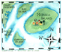
The next board is to be a map of the Coast Road area. The plan is for the board to be put up opposite St. Peter's Road, looking out to sea, to enable all our lovely visitors to know what they're looking at and what's around the corner.
I have been given an initial working brief, translated (by me) into this very rough scribble- it's going to be a bit tricky to squeeze it all in.

This is what the area really looks like (the other way up)- via google earth.
View Larger Map
Deciding what to include is a knotty conundrum. I was given a definitive list of a select few species for the St Peter's Well Meadow board. This time it's not so clearcut.
Some buildings are deemed to be landmarks, for instance the Victory pub, but if I include the Victory, what about the other pubs and cafes? - won't they feel terribly left out? How do I fairly decide which businesses to include and which not? Oh help! I shan't be able to fit everyone in.I have been given an initial working brief, translated (by me) into this very rough scribble- it's going to be a bit tricky to squeeze it all in.

This is what the area really looks like (the other way up)- via google earth.
View Larger Map
Deciding what to include is a knotty conundrum. I was given a definitive list of a select few species for the St Peter's Well Meadow board. This time it's not so clearcut.
I think the carpark, the public loos, and where to get an ice-cream are the main things visiting folk want to know.
I'd prefer to show traditional boats, our fishing fleet (Mersea is a working port), the lifeboat station, the names of the creeks, islands and mudflats (Middle Ooze is a good one!), directions hither and thither (to the village/to the strood) and maybe a shop or two.
If I include the Yacht Club, should I include the Dabchicks? How about our new red squirrels? Stacey's boat trips? the barge Dawn? the Company Shed? the Chandlery? the sailmakers? Fresh Catch? the Art Cafe? our boatyards (Peter Clarke's and the other one)? the Coast Inn? the Blackwater Pearl? the Oyster Bar, shipwrights, accordion players, carpenters, crab-fishers, Uncle Tom Cobley and all?
I'm hoping a magic fairy will devise an agreeable little list for me! -and they will, because what I keep forgetting is it is not my map, it is West Mersea Town Council's map, and so all the decisions (thank goodness) rest with them, not me. Everyone is mulling it over very hard.
What do you think I need to include? Speak now (before the next council meeting) or forever hold your peace.
*little footnote for all the non-mersea-ites:
Right at the top of this post I mentioned the Strood. The Strood is the name of the causeway which joins Mersea Island to the mainland. You can usually drive across it, but it's covered for an hour or so at high tides cutting us off from the rest of England and turning us into a real island.
* another little footnote:
This has to be a record breaking post for the number of links I have added (trying to be all-inclusive, but really, have I nothing better to do on a Tuesday morning?)! Feeling super high-techy and clever but if I have missed you out I am sorry (thinking of YOU, Spartan Wetsuits, and a myriad of others).


Hey, what a lovely post - and thanks for the link! J&G xxx
ReplyDeleteyou missed stroodcam out too! but very much looking forward to seeing the end results. Phoebe
ReplyDeleteOh Phoebe, I am sorry.
DeleteHopeless Leafy.
x
Please lovely readers, check out www.stroodcam.co.uk for exciting live strood views!
Its all very brilliant Leafy! I love it xxx
ReplyDelete